









Key points
- State of emergency declared in North Carolina by Governor Stein
- Evacuations ordered for Ocracoke and Hatteras islands
- NHC warns of life-threatening surf and rip currents along East Coast
ISLAMABAD: Hurricane Erin, churning north in the Atlantic hundreds of miles offshore, is expected to trigger a dangerous storm surge and tropical storm conditions along North Carolina’s Outer Banks and other stretches of the US East Coast.
The National Hurricane Centre warned that roads in the low-lying barrier islands may become impassable, with waves as high as 20 feet crashing ashore, according to Reuters.
The Hurricane Hunters flew straight into the eye of Hurricane Erin at Category 5 strength, capturing stunning footage of the stadium effect from inside the storm. 🌀✈️ pic.twitter.com/6Bkwec1LY0
— AccuWeather (@accuweather) August 19, 2025
The heavy surf is likely to result in significant beach erosion, it said in its 8am EDT update.
Tropical storm warnings
Portions of coastal North Carolina and Virginia were under tropical storm warnings, according to officials at the National Hurricane Centre (NHC).
“Swells generated by Erin will affect the Bahamas, Bermuda, the east coast of the United States and Atlantic Canada during the next several days,” NHC said, adding that “Erin is a large hurricane.”
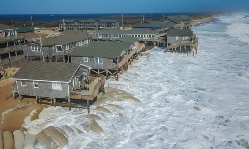
People watch as powerful waves from Hurricane Erin hit beachside homes along North Carolina’s Outer Banks on Wednesday morning. pic.twitter.com/KXwpT19xpm
— AccuWeather (@accuweather) August 20, 2025
As of Wednesday afternoon, Erin was churning northward some 245 miles (395 kilometres) southeast of North Carolina, packing maximum sustained winds of 110 mph (175 kph), the NHC said — with the possibility it could still restrengthen to a major hurricane.
“Enormous Erin”
Its unusually large size means tropical storm-force winds extend hundreds of miles from its centre, earning it the moniker “Enormous Erin” by hurricane specialist Michael Lowry, who wrote on Substack the United States was fortunate to be spared a direct hit.
Mandatory evacuation orders were in effect for Ocracoke and Hatteras Islands in North Carolina.
North Carolina Governor Josh Stein urged residents to store enough food, water and supplies to last up to five days — and to safeguard important documents like insurance policies.
“We have already pre-positioned three swift water rescue teams and 200 National Guard troops to various locations on the coast, along with boats, high clearance vehicles and aircraft,” he added.
Massive waves
Highway 12 — which runs through the scenic Outer Banks of North Carolina, a string of low-lying islands and spits already under threat from sea-level rise and erosion — could be left impassable by waves as high as 20 feet (six meters).
Last year’s Hurricane Helene caused approximately $60 billion in damage to North Carolina, equivalent to almost two years of the state’s budget, said Stein, who criticized what he called inadequate federal assistance from the administration of President Donald Trump.
Trump has mused about dismantling the Federal Emergency Management Agency (FEMA) — whose work he believes should fall to state leaders and has long been a target of conspiracy theories from the political right.
Insurance risks
The Atlantic hurricane season, which runs from June 1 to November 30, has entered its historical peak.
Despite a relatively quiet start with just four named storms so far, the National Oceanic and Atmospheric Administration continues to forecast an above-normal season.
Scientists say climate change is supercharging tropical cyclones: warmer oceans fuel stronger winds, a warmer atmosphere intensifies rainfall, and higher sea levels magnify storm surge.
There is also some evidence, though less certainty, that climate change is making hurricanes more frequent.