









Key Points
- The devastating 2025 floods exposed the province’s vulnerabilities.
- More than 2.82 million people were evacuated in Punjab.
- The province faces riverine, flash, hill-torrent and urban flooding.
- Dera Ghazi Khan and Rajanpur remain exposed to hill torrents.
- An Rs85 billion hill-torrent management project has been recommended.
- Lahore is expanding underground rainwater-storage infrastructure.
ISLAMABAD: As dark monsoon clouds gather over the plains of Punjab and families living along its rivers watch the rising water anxiously.
Farmers are worried about standing crops, residents in low-lying settlements are watching embankments nearby, while urban communities are bracing for roads and streets to become temporary waterways after hours of heavy rain. For millions in Pakistan’s most populous province, flooding is not a one-off natural disaster, but a recurring threat that can destroy homes, devastate livelihoods, disrupt transport and leave entire communities struggling to recover.
Punjab may have escaped the worst of this year’s monsoon season, with no severe flooding reported across the province and the situation remaining largely under control. But the relative calm offers little assurance that the next spell of extreme rainfall will be equally forgiving.
The devastating floods of the 2025 monsoon season exposed the vulnerability of Pakistan’s most populous and agriculturally important province to extreme rainfall, swollen rivers, hill torrents and inadequate urban drainage.
According to the National Disaster Management Authority (NDMA), the flooding was particularly severe along the Ravi, Chenab and Sutlej river systems. Between late August and early September 2025, extensive riverine flooding inundated large swaths of the province.
Major headworks including Trimmu, Punjnad, Suleimanki, Balloki and Islam were among the key points affected as floodwaters spread across agricultural plains in Multan, Muzaffargarh, Lodhran, Bahawalpur, Vehari and Rahim Yar Khan.
Beyond emergency response
The scale of the emergency was reflected in the extensive rescue and evacuation operations. An NDMA assessment recorded more than 140 deaths associated with the 2025 riverine flooding across Pakistan, with Punjab accounting for fatalities in districts including Multan, Sialkot, Muzaffargarh, Rahim Yar Khan, Lahore, Chiniot, Lodhran, Narowal, Kasur, Hafizabad and Jhang. It also reported 4,608 rescue operations in Punjab and the evacuation of approximately 2.82 million people from high-risk areas.
The question now is not simply how Punjab can respond to the next flood. A more fundamental question is whether the province can rethink its water-management system to turn excess floodwater from a recurring disaster into a resource that can be managed, stored and put to productive use.
The Punjab government approved a climate-resilience framework under its Climate Resilient Punjab Vision and Action Plan in August 2024. It allocated Rs795 billion in fiscal year 2025–26 to climate-tagged development expenditure, including approximately Rs277 billion for adaptation-related investments in sectors such as water, agriculture and urban development. Separately, the Punjab Cabinet approved Rs2.6 billion in August 2025 for rehabilitation assistance to flood-affected people.
Not all floods alike
Punjab does not face a single type of flooding. Its varied geography exposes it to riverine flooding, flash floods, hill torrents and urban flooding, each of which requires a different response.
Riverine flooding occurs when rivers such as the Chenab, Ravi and Sutlej carry high flows and water exceeds the capacity of river channels, barrages, embankments and adjoining floodplains. By early September, flooding remained a serious concern. The Provincial Disaster Management Authority reported that flash flooding had submerged 138 villages in Multan and 104 villages in Muzaffargarh, while the Sutlej affected communities throughout the river belt in areas including Vehari, Lodhran and adjoining tehsils.
Taming the hill torrents
Southern Punjab faces another major danger from hill torrents descending from the Sulaiman Range. Dera Ghazi Khan and Rajanpur are extremely exposed because heavy rainfall in the mountains can generate sudden torrents that move rapidly towards the relatively flat agricultural plains. This distinction is important when considering proposals for new dams. A mega-reservoir designed primarily for river regulation cannot automatically solve the problem of every hill torrent. The Punjab government has itself recognised the need for more localised interventions.
The provincial climate-resilience framework specifically calls for the construction of small dams and community ponds, especially in the Potohar region’s flood zones and hill-torrent areas, alongside the restoration of degraded water-storage capacity.
The Asian Development Bank (ADB) is now preparing a Punjab Hill Torrents Management Project focused on Dera Ghazi Khan and Rajanpur. Its proposed package combines structural and non-structural measures with nature-based interventions, including spate irrigation, drainage rehabilitation, watershed management, ecosystem restoration and community infrastructure. The proposal to construct 13 small dams in Dera Ghazi Khan and Rajanpur dates back to November 2019, when the Punjab government directed the Irrigation Department to conduct feasibility studies to help control flash floods. In August 2024, the Punjab government established a 21-member committee to address hill-torrent management.
More recently, on 27 October 2026, the Central Development Working Party (CDWP) recommended the Rs85 billion Integrated Hill Torrent Management project to the Executive Committee of the National Economic Council (ECNEC) for consideration.
The urban flood challenge
While rivers threaten rural communities and agricultural land, urban centres face a different challenge. Cities such as Lahore, Rawalpindi, Faisalabad, Multan, Gujranwala, Gujrat and Sialkot can experience serious inundation when intense rainfall overwhelms stormwater drainage.
Rapid urbanisation has increased the amount of paved and built-up land. Rainwater that once infiltrated soil or accumulated temporarily in open spaces now runs rapidly into drainage networks. The Punjab Inclusive Cities Programme includes investments in stormwater drainage, sewerage and wastewater treatment, with the stated objective of helping urban areas withstand floods and droughts and become more climate-resilient.

Punjab is also exploring an alternative to the conventional approach of simply draining rainwater away: capturing and storing it for subsequent use. Lahore’s underground rainwater-storage project is one example of this approach. According to media reports, three tanks had already been completed at Lawrence Garden, Kashmir Road and Sheranwala Gate. Work was underway on 10 additional tanks at locations including Gaddafi Stadium, Johar Town, Allama Iqbal Town, Garden Town, Ichhra and Tajpura.
The provincial government also approved an even larger programme involving 358 underground water-storage tanks across Punjab.
Rethinking the dam strategy
The answer may be yes — but dams alone are unlikely to solve the entire flood problem.
Shahida Kausar Farooq, an environmentalist, says that small and medium-sized dams can have important benefits in appropriate locations.
“They [dams] can temporarily hold runoff from hill torrents, reduce the speed and force of water moving downstream, provide water for agriculture and potentially contribute to groundwater recharge.” – Shahida Kausar Farooq, an environmentalist
“They [dams] can temporarily hold runoff from hill torrents, reduce the speed and force of water moving downstream, provide water for agriculture and potentially contribute to groundwater recharge,” she says.
The province is also considering small-dam and canal-rehabilitation schemes. The 2026-27 development planning includes proposals relating to small dams in Potohar, hill-torrent management in Dera Ghazi Khan and Rajanpur and rehabilitation of canal systems. However, reservoirs have limitations, as they have finite storage. Sedimentation can reduce their effective capacity over time. Poorly designed or maintained structures can create new risks. Dams can also alter downstream flows and ecosystems. Most importantly, a dam built in one location cannot protect a city or agricultural district from every possible source of flooding.
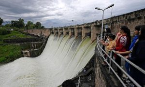
For instance, a Lahore cloudburst is fundamentally a stormwater management problem. A hill torrent in Dera Ghazi Khan is a watershed and flood-routing problem. A massive Chenab flood at Qadirabad is a river-management problem. Each requires a different set of interventions.
Punjab has an extensive network of barrages, canals and embankments. These structures are essential, but flood-protection infrastructure can also create a false sense of security if land-use controls are weak.
When people construct homes, commercial buildings or other infrastructure inside natural flood corridors, the potential consequences of a major flood become much greater. The objective should not be simply to construct higher and stronger embankments. It should also be to keep people and valuable infrastructure out of areas that naturally carry or temporarily store floodwater. This requires effective land-use planning, mapping of floodplains and enforcement against encroachment.
The enormous canal system in Punjab is another potential part of the solution. The irrigation network was developed to distribute water for agriculture. But a modern water-management system could use improved canal infrastructure, designated storage areas and controlled diversions to manage excess water.
The ADB has identified rehabilitation and upgrading of several Punjab canal systems, including Rasul-Qadirabad, Qadirabad-Balloki and Balloki-Suleimanki.
Working with nature
A further component of an integrated flood-management strategy would be the restoration of natural systems that absorb, store or slow excess water. Wetlands, floodplains, riparian forests, natural depressions and other green areas can temporarily store or slow water.
International flood-management experience combines engineered infrastructure with nature-based measures. The World Bank noted that forests, wetlands and other natural systems can help reduce flooding, erosion and other climate-related risks. Such findings highlight the potential of combining conventional flood-protection infrastructure with nature-based measures to strengthen long-term climate resilience.
For Punjab, this could mean identifying areas where water can safely spread temporarily rather than attempting to confine every flood to a narrowly engineered channel. Such areas would need to be scientifically identified and mapped and protected from encroachment. Flood management is not only about dams, barrages and embankments. Knowing where floodwater is coming from, how quickly it is moving and which communities are likely to be affected can save lives.

The World Bank’s recent assessment of lessons from Pakistan’s 2025 floods emphasises strengthening the entire early-warning chain, ranging from risk assessment and monitoring to forecasting, communication, warning dissemination and community response.
Punjab can expand automated river gauges, rainfall monitoring and telemetry at barrages, satellite-based flood mapping and district-level forecasting. But the effectiveness of these systems ultimately depends on whether warnings reach the people most at risk.
Connecting the missing pieces
A more comprehensive flood-resilience system would combine several interconnected measures.
Punjab already has some elements of such a strategy in place and does not have to start from scratch. It has publicly announced a climate-resilience framework to identify small dams and community ponds; and to restore water-storage capacity, artificial wetlands and groundwater recharge. The province is developing urban rainwater-storage schemes. The World Bank is supporting improved urban drainage and resilience in Punjab’s secondary cities.
Meanwhile, the proposed ADB Hill Torrents Management Project for Dera Ghazi Khan and Rajanpur combines structural infrastructure with drainage, watershed management, ecosystem restoration and nature-based solutions. The challenge is less about finding a single new idea and more about connecting these initiatives into one coherent provincial flood-resilience strategy.
A new flood paradigm
Every year, the provincial government confronts a familiar set of questions: How high will the rivers rise? Which embankment is vulnerable? Which villages have to be evacuated? How many crops will be lost? Which city roads will become impassable?
But a more fundamental question needs to be addressed well before the monsoon begins: Where should Punjab allow water to go? If the answer is only ‘away from populated areas’, the province will remain trapped in a cycle of emergency response.
The province’s future flood policy may need to move from a dam-centric approach towards a networked water-management model — one that stores some water, slows its flow, redirects it where technically feasible, gives it room to spread safely and warns communities about risks that cannot be prevented.
The 2025 floods demonstrated the scale of the threat. The task now is to ensure that the next extreme monsoon does not expose the same vulnerabilities or inflict a similar level of devastation.