

Monitoring Desk
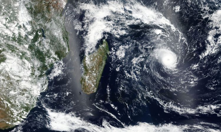
ISLAMABAD/WASHINGTON: The remnants of Tropical Cyclone Freddy continue to wreak havoc in parts of southeast Africa. Initially forming as a disturbance embedded within a monsoon trough on Feb 5, the system continues to bring torrential rain. It’s no longer classed as a tropical cyclone, with sustained wind speeds below 74miles per hour.
Having spent three weeks moving westwards across the Indian Ocean before affecting Mauritius, Madagascar, and Réunion, Freddy made landfall in Mozambique on February 24, bringing winds of 50mph.
For mainland Africa, it’s the torrential rainfall rather than the wind that is the main problem. Heavy rain has fallen in southern parts of Mozambique since Friday, with eastern places of Zimbabwe hit by torrential rain over the weekend. Most of the southern half of Mozambique has had 200mm to 500mm of rain, with more than 200mm in parts of south-east Zimbabwe. The system will stall over the region over the next few days, bringing further heavy rain.
By Thursday, most of eastern Zimbabwe is likely to be hit by 200mm to 400mm of rain, with 300mm to 600mm across most of the central and southern Mozambique. It is to mention here, there is about 600mm of rain in London annually. It’s no surprise this already caused devastating floods. From Thursday, the remnants of Freddy look to drift back eastwards into the Mozambique Channel, and there is a potential for it to strengthen again before revisiting Madagascar by the weekend.
Weather condition
After large temperature contrasts between southern and northern parts of the United States the previous week, this week, the dissimilarity will be felt between the west and east. A large place of high pressure in the eastern North Pacific Ocean will drive extremely cold northerly winds into western parts of the United States, resulting in temperatures 10C to 15C below average later that week. Low-pressure systems developing in the east of the Rockies would allow relatively warm south-westerly winds to affect much of the eastern United States, with temperatures here rising 10C to 15C above normal. Temperatures are expected to exceed 40C in south Texas by Thursday.