


ISLAMABAD: Pakistan’s newly launched Earth-observation satellites are stepping in to fill part of the gap—detecting floods within hours, tracking reservoir changes, and integrating imagery with ground sensors and weather models to bolster forecasts in the absence of real-time alerts.
The shift follows India’s abrupt suspension in April of the decades-old upstream flow data exchange under the Indus Waters Treaty, a move it linked to the Pahalgam incident.
The twin platforms—PRSC-EO1 (Pakistan’s first domestically built optical satellite launched in January 2025) and PRSS-1 (launched into orbit from China on August 1)—bring high-resolution imaging, rapid revisit cycles, and multi-sector applications ranging from disaster relief to precision agriculture.
Officials and experts say they cannot fully replace the in-advance upstream flow alerts once provided by India; still, they do give Pakistan a bird’s-eye view of its river systems.
Bridging a dangerous gap
Under the 1960 treaty’s long-standing confidence-building measures, India provided Pakistan with upstream flow readings and advance notices of major water releases, helping downstream managers keep their heads above water during sudden flood surges.
While the loss of real-time operational data leaves a critical gap, the new satellites are allowing Pakistan to detect and map inundation within hours of a flood, using imagery fine enough to pinpoint damaged embankments and stranded communities.
They also enable the tracking of reservoir levels and river swelling between passes, providing early visual clues of upstream changes.
For the first time, we can observe what’s happening upstream and downstream without waiting for outside data.” – A senior official
In addition, the satellites integrate images with ground sensors and weather models to strengthen flood forecasts in the absence of upstream alerts.
Multi-sector payoffs
Beyond flood defence, both satellites serve broader national needs: monitoring crop health, guiding irrigation schedules, assessing environmental change, and mapping infrastructure, particularly under the China-Pakistan Economic Corridor.
Their data is being fed into civil defence and planning departments to speed up decision-making during emergencies.
SUPARCO engineers say PRSS-1’s sub-metre panchromatic resolution and PRSC-EO1’s real-time tasking ability offer a watchful eye over the Indus Basin and beyond.
“For the first time, we can observe what’s happening upstream and downstream without waiting for outside data,” said a senior official.
No full substitute
Experts, however, caution that satellite pictures show what has already happened or is unfolding—not what upstream dam operators plan to do next.
“You can see a reservoir rising, but without operational coordination, you don’t know when they’ll open the gates,” said a former water commissioner.
While the loss of real-time operational data leaves a critical gap, the new satellites are allowing Pakistan to detect and map inundation within hours of a flood, using imagery fine enough to pinpoint damaged embankments and stranded communities.
For now, Pakistan is capable of fusing satellite feeds with its hydrological models, commercial imagery, and international datasets such as Europe’s Sentinel-1 radar imagery, which can penetrate cloud cover and darkness.
At a glance
Beyond flood alerts, the satellites deliver multi-sector benefits: onboard processing for near-instant imagery; transparency tools for monitoring infrastructure and agriculture; glacier and snow tracking in the headwaters of the Hindu Kush–Karakoram–Himalaya; and support for public health planning by mapping vulnerable populations and potential outbreak zones.
Beyond floods
The scope extends further into geology and resources. Multispectral imagery can map surface formations, trace fault lines, and detect mineral signatures—guiding seismic surveys and mineral exploration.
While satellites cannot directly see underground, they can help focus costly fieldwork on the most promising sites, improving efficiency in tapping Pakistan’s mineral wealth.
Officials admit that these capabilities will not instantly match the speed or granularity of treaty-based data, but could restore a significant measure of strategic control over water, environment, and resource intelligence when combined with ground sensors and international datasets.
Eyes on the future
Officials say the new hardware is part of a longer-term Space Vision 2040 aimed at expanding the satellite fleet for development, science, and security.
But with monsoon volatility rising and diplomatic water channels closed, the immediate challenge is to make every second count and leave no stone unturned in wringing every warning from these new eyes in the sky.
FACT BOX
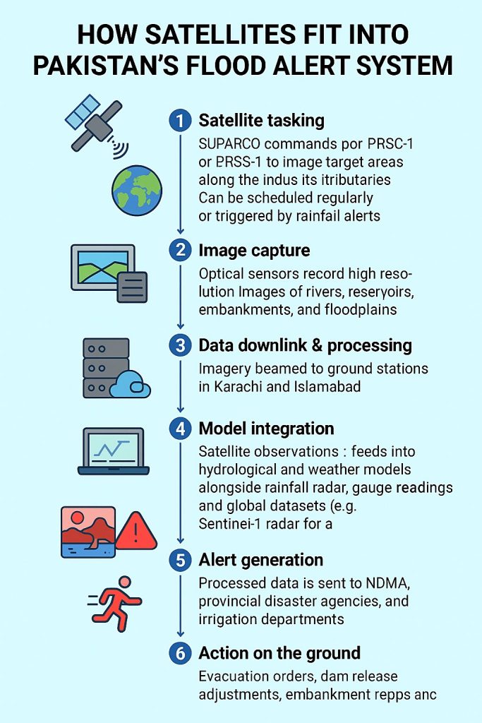
🛰 HOW SATELLITES FIT INTO PAKISTAN’S FLOOD ALERT SYSTEM
1️⃣ Satellite tasking – SUPARCO commands PRSC-EO1 or PRSS-1 to image rivers and floodplains, either on a schedule or in response to weather alerts.
2️⃣ Image capture – Optical sensors record high-resolution views of riverbanks, reservoirs, and infrastructure.
3️⃣ Downlink & processing – Data beams to Karachi and Islamabad ground stations, where software flags changes in water extent or damage.
4️⃣ Model integration – Satellite readings join rainfall, gauge, and radar data in flood prediction models.
5️⃣ Alert generation – NDMA and provincial agencies receive severity maps and forecasts.
6️⃣ Action – Evacuations, embankment repairs, and relief deployment guided by the latest satellite-aided warnings.
📦 FACT BOX — PAKISTAN’S NEW EYES IN THE SKY
PRSC-EO1
- Launch date: 17 Jan 2025
- Launch site: Jiuquan, China (Long March-2D rocket)
- Type: Pakistan’s first domestically built electro-optical satellite
- Resolution: Sub-metre (panchromatic), multispectral imaging
- Revisit cycle: On-demand tasking, near-real-time downlink
- Key uses: Flood mapping, disaster relief, crop monitoring, urban planning
PRSS-1
- Launch date: 1 Aug 2025
- Launch site: Xichang, China (Kuaizhou-1A rocket)
- Type: High-resolution remote sensing satellite
- Resolution: ~0.98 m panchromatic, ~2.89 m multispectral
- Revisit cycle: ~4 days
- Key uses: River and reservoir monitoring, environmental change detection, CPEC infrastructure mapping, precision agriculture