


Key Points
- Western disturbance enters Balochistan on 19 Dec
- Rain, thunderstorms and snowfall from 20–22 Dec
- Moderate to heavy snowfall in upper KP, GB, Kashmir
- Risk of road closures, landslides and avalanches
- Smog/fog persists in Punjab and Sindh
ISLAMABAD: The Pakistan Meteorological Department (PMD) has predicted rain, wind, thunderstorms, and snowfall over hilly areas across western and upper parts of the country from 20th to 22nd December 2025, under the influence of a western disturbance entering Balochistan on 19th December.
According to the Met Office, the weather system will first affect western regions before spreading to the upper and central parts of the country, bringing widespread precipitation, snowfall in mountainous areas, and cold conditions.
Rain with wind-thunderstorms and snowfall over hills is expected in several districts of Balochistan, including Quetta, Ziarat, Chaman, Pishin, Qilla Abdullah, Qilla Saifullah, Zhob, Harnai, Musakhel, Kalat, Khuzdar, Chagi, Kharan, Washuk, Panjgur, Kech, Awaran, Turbat, Gwadar, Jiwani and Lasbella from 19th evening to 20th December.
#Rain–#Wind/#Thunderstorm (#Snowfall over the hills) with isolated Hailstorm predicted in upper/central parts from 17th (night) to 21st February
Strong westerly wave is likely to approach western parts on 17th (night) and may grip upper/central parts of the country on 18th Feb pic.twitter.com/z1e1NMnngz
— Pak Met Department محکمہ موسمیات (@pmdgov) February 16, 2024
In Khyber Pakhtunkhwa from 20th night to 22nd December, rain-wind/thunderstorms with moderate snowfall in upper areas are expected in Chitral, Dir, Swat, Shangla, Kohistan, Mansehra, Abbottabad, Haripur, Buner, Bajaur, Mohmand, Khyber, Orakzai, Kurram, North and South Waziristan, as well as plain areas including Peshawar, Charsadda, Nowshera, Swabi, Bannu, Karak, D.I. Khan, Tank, and Kohat, with occasional breaks.
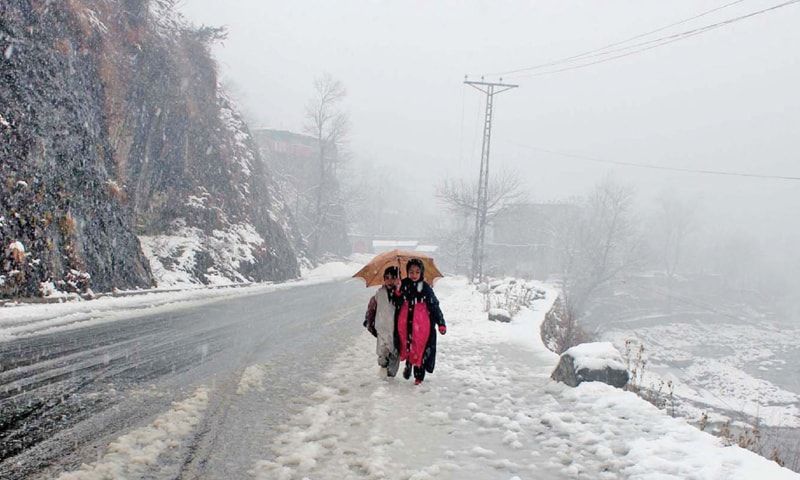
Moderate to locally heavy snowfall along with rain-thunderstorms is expected in Gilgit-Baltistan (Diamir, Astore, Ghizer, Skardu, Hunza, Gilgit, Ghanche and Shigar) and Azad Kashmir (Neelum Valley, Muzaffarabad, Poonch, Hattian, Bagh, Haveli, Sudhanoti, Kotli, Bhimber and Mirpur) from 20th night to 23rd morning.
In Punjab rain-wind/thunderstorms are likely in Islamabad, Rawalpindi, Potohar region, Mianwali, Bhakkar, Noorpur Thal and Layyah from 20th evening to 21st December. Snowfall is also expected in Murree and Galliyat during the night of 20th to 21st December.
Meanwhile, cloudy conditions with drizzle may persist in Lahore, Gujranwala, Faisalabad, Sialkot, Narowal, Sheikhupura, Gujrat, Hafizabad, Mandi Bahauddin, Sargodha, Khushab, Multan, Jhang, D.G. Khan and Toba Tek Singh on 20th and 21st December.
Most parts of Sindh will experience partly cloudy to cloudy weather on 19th and 20th December, while smog and fog conditions are likely to persist in upper Sindh.
Possible Impacts and Advisories
The Met Office has warned that snowfall may cause road closures and slippery conditions in Naran, Kaghan, Swat, Dir, Kohistan, Mansehra, Abbottabad, Shangla, Astore, Hunza, Skardu, Murree, Galliyat, Neelum Valley, Bagh, Poonch and Haveli from 20th to 22nd December.
There is also a risk of landslides and avalanches in upper Khyber Pakhtunkhwa, Gilgit-Baltistan and Kashmir.
Tourists and commuters are advised to avoid unnecessary travel, remain cautious, and stay updated with local weather advisories. Smog and fog are expected to continue affecting central and southern Punjab and upper Sindh, potentially reducing visibility.