


KARACHI: As expected, powerful tropical cyclone Biparjoy slightly nudged towards northeast on Wednesday, sparing the metropolis of Karachi from its hit, and kept on barrelling towards the India-Pakistan border to make landfall today (Thursday) yet Karachi is on high alert to cope with any untoward situation.
Climate Change Minister Sherry Rehman said that because of evolving nature of the cyclone, the landfall was expected in the morning, against the earlier forecast of the landfall in the afternoon.
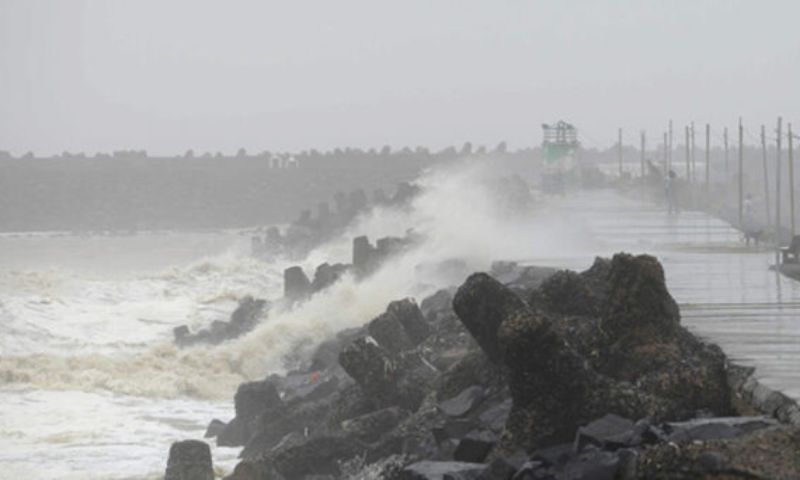
According to the alert issued by the Pakistan Meteorological Department (PMD), the cyclone moved closer to Sindh’s coast. By Wednesday night, it was located in the Arabian Sea at a distance of about 310 kilometres from Karachi.
Biparjoy made a turn northeastward and was staying on its projected path, the PMD said. It forecast that the strong winds, storm surges and lashing rains would hammer a 325-kilometre coastal stretch between Karachi and Mandvi in Indian state of Gujarat.
Though storm Biparjoy’s intensity has decreased a little, yet it is likely to hit Sindh’s Keti Bandar today (Thursday) at 11am.
According to Minister for Climate Change Sherry Rehman as many as 66,000 people have been evacuated to safer places from Sindh’s coastal areas. She also requested the people to cooperate with authorities and added that all rescue agencies are prepared for relief operations. “The true form of the cyclone will be known tomorrow,” she said on Wednesday.
According to the government officials, Thatta, Tharparkar, Sujawal and Badin districts will be hit the hardest by the cyclone as the Biparjoy is moving away from Karachi. In its latest update, the Pakistan Meteorological Department (PMD) said that cyclone Biparjoy over northeast Arabian Sea has moved nearly northeastward during the past six hours and now lies near latitude 22.1°N and longitude 66.9°E at a distance of about 300km south-southwest Thatta, 310km south of Karachi and 240km south-southwest of Keti Bandar. The cyclone was previously 370km south of Karachi.
Under the existing upper-level steering winds, the cyclone will likely keep tracking Northeastward and cross between Keti Bandar (southeast Sindh) and Indian Gujarat coast on June 15 (today) evening with packing winds of 100-120km per hour and gusting 140km per hour.
The country’s coastal regions were on high alert Wednesday, with tens of thousands of people evacuated to stave off the impact of the cyclone, which is expected to make landfall today.
Biparjoy is inching closer to India and Pakistan, prompting authorities to take preventive measures to minimise the damage it may cause to life and property. The cyclone is likely to reduce its strength after hitting the land, but the Pakistan Meteorological Department (PMD) has asked fishermen not to venture into the open sea until Saturday.
Several low-lying settlements in Sujawal and Thatta, most of which were already evacuated, saw high-tide flooding. Rising seawater levels in other fishing villages, as Karachi’s Ibrahim Hyderi and Badin, panicked people. Despite warnings, still, many people are reluctant to leave their homes.
On Wednesday night, dozens of people at a relief camp set up at an army public school in Badin protested over poor conditions at the site and blocked the road, according to media reports.