

KEY POINTS
- Punjab becomes the first province in Pakistan to use thermal imaging drones and satellite tech for flood rescue operations
- Over 490 people were rescued in complete darkness using heat-detecting drones in flood-hit areas
- The disaster response blends real-time surveillance, AI mapping, and digitized relief distribution
ISLAMABAD: As Pakistan battles its worst flooding in decades, the country’s Punjab province has turned to thermal imaging drones, satellite surveillance, and real-time command systems to locate and rescue survivors—marking the first use of such advanced technology in the country’s disaster response.
The initiative marks the first time such cutting-edge technology has been used in flood rescue operations in Pakistan.
With nearly two million people affected by record monsoon rains and floodwaters spilling into Punjab from across the Indian border, the province faces a full-blown humanitarian crisis.
Yet amid the devastation, Pakistan is witnessing a dramatic shift in how disasters are being managed—powered by innovation and urgency.
What is thermal technology?
Thermal technology is a kind of heat-sensing vision, a tool that sees the world not through light, but through warmth.
Using infrared (IR) sensors, it detects heat emitted by all living beings- humans, animals, even machines, and transforms those invisible temperature signals into glowing thermal images or heat maps.
These visuals can cut through darkness, fog, smoke, and even heavy rain, turning night into day for rescuers on the ground and in the sky.
How it works during floods
When floodwaters rise and visibility disappears, thermal technology becomes a lifeline. It allows rescue teams to spot stranded survivors by detecting the heat of their bodies, even when they’re hidden by water, rooftops, trees, or wreckage.
Here’s how it’s saving lives:
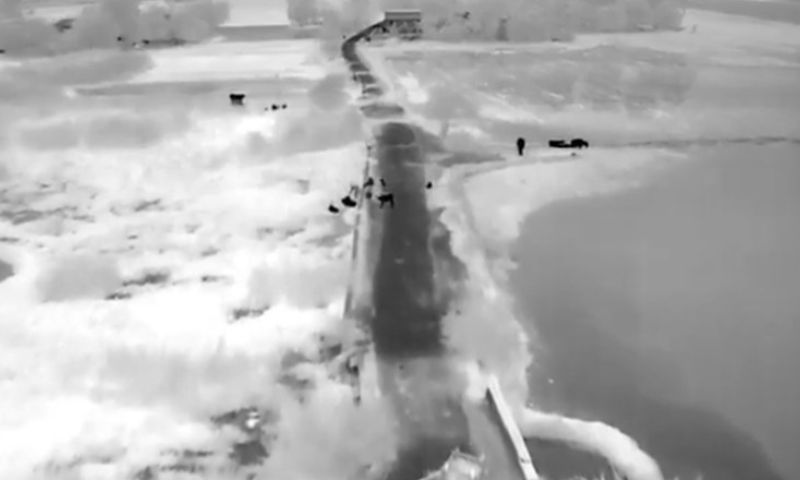
Drones fitted with thermal cameras soar over flooded zones, pinpointing human heat signatures where traditional cameras see nothing.
People clinging to rooftops, trapped inside homes, or sheltering in trees can be identified by the warmth they radiate, making the invisible, visible.
Live thermal feeds beam directly to command centers, enabling rescuers to act quickly and head straight to where they’re needed most.
By removing the guesswork, thermal imaging drastically reduces response time, helping teams navigate dangerous floodwaters swiftly and safely.
For the first time, thermal imaging drones have been deployed to locate and rescue people in complete darkness, especially in remote and inaccessible areas. Over the past week, more than 490 individuals have been located and safely evacuated at night thanks to this advanced thermal technology.
On 31 August 2025, Safe City Muzaffargarh identified a stranded family at Mouza Doaaba on river Chenab through thermal drone monitoring. The alert was shared with police, who promptly rescued the family of 8 people along with their animals. pic.twitter.com/GN8UVindEk
— Maryam Nawaz Sharif (@MaryamNSharif) August 31, 2025
Drones equipped with thermal sensors enabled night-time rescue missions in districts including Okara, Jhang, Atharah Hazari, Shorkot, and Ahmadpur Sial. These drones detect body heat even when human presence is obscured by darkness, water, or debris.
Among the rescued
- Thatta Jabanran: 85 people
- Alipur: 70
- Jogira Bocheran: 80
- Kharoda Bakar: 30
- Wajidabad Shah Jiwana: 10
- Dab Kalan (Shorkot): 20
- Darbar Abdul Razaq (Ahmadpur Sial): 4
- Wali Muhammad Jhandeer: 45
- Dozens across Jhang City Band, Pindi Mohalla, Vijhlanran, Chak Noon, and Khalra.
“This is a revolutionary step in Pakistan’s emergency response,” said Maryam Nawaz. “Thermal imaging has allowed us to reach people we would never have found in time with the naked eye. Every life is precious, and now, every life is visible.”
The Punjab government has evacuated over 600,000 people and nearly 500,000 livestock, while maintaining uninterrupted operations at hospitals through prioritized dewatering efforts.
Technology meets humanity
Beyond thermal drones, Punjab’s response includes:
- Real-time road connectivity monitoring to guide rescue vehicles
- Live satellite and GIS data to predict water movement
- Digitally managed food and aid distribution, including three hot meals daily at camps
- Special operations to protect key cultural and religious sites, such as the Gurdwara Darbar Sahib in Kartarpur, which was dewatered and restored after flooding
This marks the first integrated disaster tech deployment in Pakistan’s history, one that could serve as a model for future crises in a climate-vulnerable region.
Climate reality
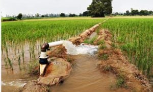
The floods, triggered by 26.5% above-average rainfall and aggravated by India’s upstream water releases, have submerged vast tracts of farmland and villages in Punjab, the heart of Pakistan’s agricultural economy.
With wheat, rice, and cotton fields underwater, the province faces the dual threat of displacement and food insecurity in the months ahead.
Climate crisis driving disaster
The devastating floods come amid warnings that climate change is accelerating natural disasters in South Asia.
This year, Pakistan received 26.5% more rainfall than average, according to Met Office, while India’s release of upstream dam water has further intensified the flooding in Punjab.
The province, home to 150 million people and a major agricultural hub, is now bracing for a secondary crisis: looming food shortages.
Crops such as wheat, rice, and cotton lie underwater, threatening both local livelihoods and national food security.