

KARACHI: The Sindh government blocked Karachi’s seaview road to traffic on Monday to prevent people from heading out into the open sea as the Pakistan Meteorological Department (PMD) has predicted that Cyclone Biparjoy, now classified as an “extremely severe cyclonic storm”, was approaching towards the coastal city and was currenly hovering at a distance of 600 kilometres.
In addition, the provincial government also initiated an evacuation drive from the coastal areas of Badin while moving the residents to safe places to avoid any human loss.
Meanwhile, addressing a press conference in Karachi, Sidh Chief Minister Murad Ali Shah stressed the need to prepare for dealing with the cyclone adding that direction of the cyclone was changing and while it was not directed towards Karachi, still there would be the possibility of strong winds and rainfall of approximately 60mm with winds at 70-kilometre per hour.
The chief minister also informed that the provincial government has taken contingency measures while removing billboards and instructions had been issued to stop construction work, especially after June 14 till the issuance of subsequent advisory.
Met Office on Cyclone
The Met Office has predicted heavy rain, thunderstorm, and winds in Thatta, Tharparker, Umerkot, Sujawal, and Badin districts from June 13-17
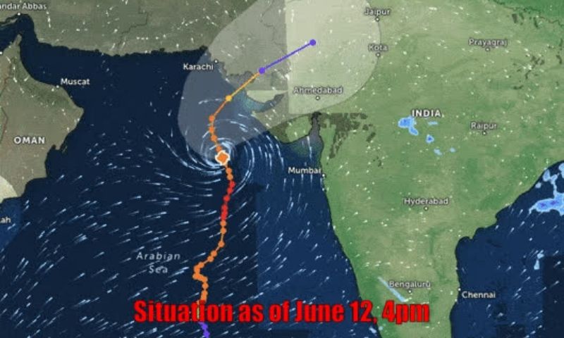
Earlier, the Met Office in its advisory said that the cyclone had moved further northward during the last 12 hours and was persistent at a distance of about 600km south of Karachi, 580km south of Thatta and 710km southeast of Ormara.
The metrological department added that the cyclone’s maximum sustained surface winds were about 160-180km per hour while gusts as high as 200km/h were around the system center. Sea conditions were “phenomenal around the system center with waves up to a maximum height 35-40 feet”, it added.
The Met Office also warned citizens to keep themselves away from the coastal areas particularly in Thatta, Sujawal, Badin, Tharparker and Umerkot districts, where rain with winds of 80-100km/hour expected from June 13-17.
It also predicted heavy dust/thunderstorm rain with winds of 60-80km/h in Karachi, Hyderabad, Tando Muhammad Khan, Tando Allayar, Sanghar and Shaheed Benazirabad districts from June 14 to 16.
Meanwhile Sindh Chief Minister Murad Ali Shah also conducted an aerial inspection of the coastline along Badin, Sujawal and Thatta, whereas Minister for Local Government Nasir Shah, chief secretary Sohail Rajput and PDMA Director General Salman Shah also accompanied the chief minister.
* وزیراعلیٰ سندھ سید مراد علی شاہ سمندری طوفان کے پیش نظر سجاول کی ساحلی پٹی کا دورہ
* وزیراعلیٰ سندھ نے سجاول، ٹھٹہ اور بدین کی ساحلی پٹی کا فضائی معائنہ کیا pic.twitter.com/G8n6g4x5iH
— Sindh Chief Minister House (@SindhCMHouse) June 12, 2023
Later amid a briefing in Hyderabad, the Commissioner apprised the CM that the cyclone is expected to hit the Sindh coast on June 15 and its impact would reduce till June 17-18 adding that when the storm would hit the coast, the sea waves would possibly rise in the area by four to five meters. He also informed the minister that 50,000 people from the villages nearby Shah Bunder, Jati and Keti Bunder would be evacuated ahead of the cyclone.
The chief minister was also informed about the evacuation of 2,000 people from the islands of Shah Bunder to safe places and a significant number of people were also assisted to move from the village of Bhagra Memon near Badin’s Zero.
Thatto (June 12th, 2023) Sindh Chief Minister Syed Murad Ali Shah during his visit to Keti Bandar being briefed about the status of cyclone. pic.twitter.com/4z8tHR4Iy8
— Sindh Chief Minister House (@SindhCMHouse) June 12, 2023
Subsequently, Shah directed the district administration, the Navy and Maritime Security to help the residents and directed all relevant derpartment to remain alert for immediate response.