

Monitoring Desk
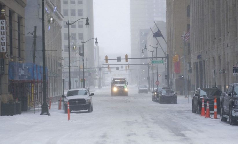
ISLAMABAD/MARYLAND: A powerful winter storm coupled with bitter cold and gusty winds pounded several US states, with Michigan being the most-hit state. The storm has rendered nearly a million people nationwide without power on Thursday.
According to media reports, Michigan bore the brunt of the power outage on Thursday night, with more than 820,000 businesses and houses left cold into the evening, as the state faced one of the worst heavy storms in decades. DTE, one of the biggest power providers in the state, reported “heavy amounts of damage” to power infrastructure after snow storm roughly three-quarters of an inch thick accumulated in some places.
“That is a level we have not seen nearly 50 years,” Matt Paul, executive vice president of distribution operations at DTE, said, adding that the extreme ice weather downed more than 2,000 power lines and caused utility poles to snap.
It is still being determined how quickly the dangerous circumstance can be addressed. Along with the perils of exposure posed on those left without energy resources during the ice storms, the downed lines create hazards all on their own.
Lt Ethan Quillen, the firefighter with the Paw Paw Volunteer Fire Department, was killed after being struck by live wires as he responded to a call Wednesday, Michigan state police officials said.
Dangerous ice storm
The dangerous ice storm system has prompted the National Weather Service to problem winter weather advisories to swaths of the US, covering places where more than 13 million citizens live.
Temperatures are expected to fall down to 40F below average across several regions of the US, leaving many places, especially in the high plains, bracing for the sub-zero situation, travel hazards, and more power outages.
“A prolonged major winter storm would continue to bring widespread heavy snow and blizzard conditions to portions of the west and the northern Plains/Great Lakes,” the NWS warned in a forecast Thursday, adding the storm could produce up to 2in of snow per hour with winds as high as 50mph “to drive important impacts that would include major disruptions to travel, infrastructure, livestock, and recreation”.
Periods of snow, gusty winds, & an icy wintry mix will continue to cause treacherous travel conditions from the Upper Midwest to the Northeast today. Frigid wind chills are also expected in wake of the storm. Please see the latest Key Messages for additional information. pic.twitter.com/sIz33Vp2lJ
— NWS Weather Prediction Center (@NWSWPC) February 23, 2023
Few places would be untouched by wild weather. As the north plunges into the bitter cold, stretches across the south would see record heat with temperatures pushing past 80F. Long-standing record high temperatures have already broken in the midwest, mid-Atlantic, and southeast.