

GUPIS-YASIN, Pakistan: At first light, when the serrated peaks above Roshan Talidass briefly blush pink, Samina Bibi steps out of her mud-brick home.
She is not drawn by beauty. Instead, she scans the slopes — the ice lines, the narrow channels where meltwater whispers before it roars.
At 43, she has learned to read the mountains the way others read calendars — by sound, by silence, by the shape of fear.
Samina lives in Roshan Talidass village of Gupis-Yasin district — about 100 kilometres west of Gilgit city, the provincial headquarters of Gilgit-Baltistan.
The settlement, wedged deep inside the Ghizer Valley, is home to nearly 2,000 people, with another 1,500 scattered across surrounding hamlets — all perched on the flashpoint of glacial outbursts.
Her home stands beside fields that once yielded wheat, potatoes and fodder for livestock.
For generations, agriculture and animals formed the economic spine of life here, sustained by predictable glacier melt that followed seasonal rhythms, like clockwork.
When the rhythm breaks
But the rhythm has begun to collapse.
Today, fear has woven itself into Samina’s daily routine, becoming the thread that binds each season together. She does not fear conflict or crime. What haunts her is water — silent, shifting and unforgiving.
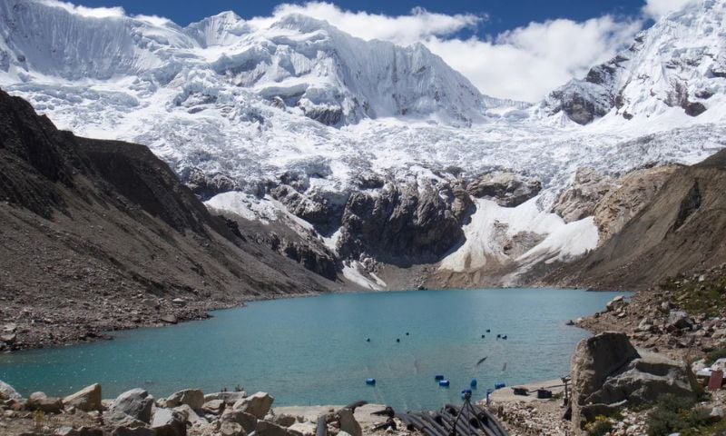
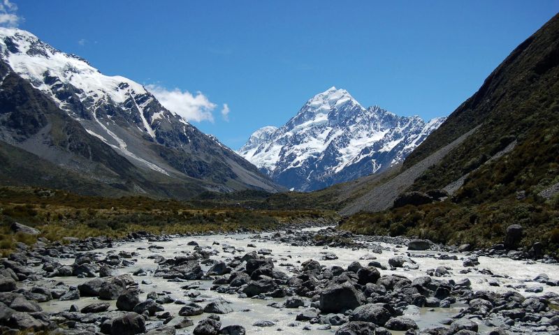
High above her village, massive glaciers are melting faster than memory can keep up with. New glacial lakes are forming; older ones are swelling.
One sudden breach — one collapse of ice or rock — could send walls of water racing downstream, wiping entire settlements off the map in minutes.
“We think about our lives, our homes, our fields, our animals — everything. This fear is not imagined. It is real, and it grows every summer,” Samina says quietly.
Frozen lifelines fracture
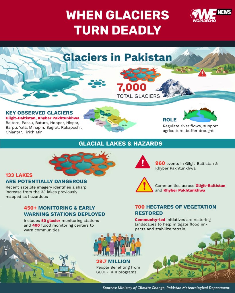
According to data compiled by Pakistan’s Ministry of Climate Change, the country hosts more than 7,000 glaciers, making it home to one of the largest concentrations of ice outside the polar regions.
Most of these glaciers are spread across Gilgit-Baltistan and Khyber Pakhtunkhwa, feeding the Indus River system that sustains hundreds of millions downstream.
We think about our lives, our homes, our fields, our animals — everything. This fear is not imagined. It is real, and it grows every summer.” — Samina Bibi, resident of Roshan Talidass, Gupis-Yasin
For centuries, these glaciers functioned as natural water towers — regulating river flows, supporting agriculture, and buffering drought. Today, rising temperatures are turning those lifelines into sources of destruction.
But the danger may be far greater than previously believed.
Under an earlier government-supported climate risk mapping initiative, 33 glacial lakes across 24 valleys were officially classified as hazardous, believed to pose serious flood risks.
But on the other side, recent satellite imagery shared by government officials suggests that as many as 133 glacial lakes could now be potentially dangerous — a fourfold increase from earlier estimates.
The data, shared informally with the media, is considered credible within government circles — though officials say it will not be made public until ground-based field assessments are completed.
A silent violence
Glacial Lake Outburst Floods (GLOFs), occur when natural dams made of ice or loose rocks suddenly collapse, releasing massive volumes of water, mud and debris downstream — leaving little room for escape.
According to the Ministry of Climate Change, Pakistan has 3,044 glacial lakes, dozens of which are considered dangerous. Since 2000, nearly 960 GLOF events have been recorded in Gilgit-Baltistan and Khyber Pakhtunkhwa.
Each flood leaves behind a trail of destruction: collapsed houses, washed-away roads, destroyed crops, human fatalities and dead livestock.
For mountain communities, recovery is slow, partial and often next to impossible, forcing families to start from scratch time and again.
Tracking the melt
Pakistan’s glaciers behave differently from many elsewhere. Most are debris-covered, with rocks and dust altering melt rates.
Since 2006, the Pakistan Meteorological Department (PMD) has monitored glaciers using Automatic Weather Stations installed between 3,000 and 5,000 metres.
Observed glaciers include Baltoro, Passu, Batura, Hopper, Hispar, Barpu, Yala, Minapin, Bagrot, and Rakaposhi, as well as Chiantar and Tirich Mir in the Hindu Kush.
Baltoro and Passu glaciers receive special attention due to contrasting melt patterns.
Heat creeps higher
Data presented to the former Prime Minister’s Special Assistant on Climate Change, Malik Amin Aslam, shows a rising snowline — snow now falls higher up the mountains, while rain replaces it at lower elevations.
Early warning systems can save lives, but they do not protect homes, farms, or infrastructure. What we need is prevention, planning, and preparedness— not just alarms that ring after damage is inevitable.” — Shahida Kauser Farooq, environmentalist and conservationist, Gilgit-Baltistan
This shift accelerates glacier melt, fuels the formation of new glacial lakes and expands existing ones.
Supra-glacial and sub-glacial lakes are especially dangerous, as they fill and drain invisibly, leaving communities unaware until disaster strikes.
Another hidden threat is black carbon, produced by wood burning in nearby villages. The soot settles on glaciers, darkening their surface and absorbing heat, which accelerates melting — a slow poison with long-term consequences.
When ice turns deadly
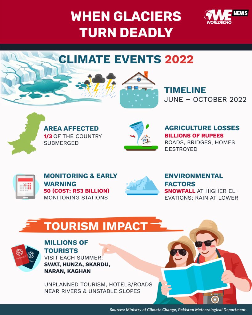
The scale of climate vulnerability became impossible to ignore in 2022. From June to October, record-breaking heatwaves accelerated glacier melt, followed by intense monsoon rains and atmospheric river events that overwhelmed rivers nationwide.
Nearly one-thirds of the country was submerged. More than 1,700 people lost their lives. Millions were displaced.
Agriculture suffered losses running into billions of rupees. Roads, bridges, and homes collapsed like houses of cards.
While Sindh, Balochistan and Khyber Pakhtunkhwa bore the brunt, the northern mountains were under extraordinary stress, feeding floodwaters downstream.
The message was unmistakable: climate change is no longer a distant threat. It is already at Pakistan’s doorstep.
Early warning gaps
According to official federal government data, 50 glacier monitoring stations have been established at a cost of Rs3 billion, alongside 400 special flood monitoring centres that track water levels and issue alerts.
Satellite-based monitoring of major glaciers has already been completed.
These systems help provide precious minutes — sometimes hours — to evacuate.
But Shahida Kauser Farooq, an environmentalist and conservationist working in Gilgit-Baltistan, warns they are not enough.
“Early warning systems can save lives, but they do not protect homes, farms, or infrastructure. What we need is prevention, planning, and preparedness— not just alarms that ring after damage is inevitable.”
Turning warning into safety
Pakistan’s first Glacial Lake Outburst Flood (GLOF-I) project was launched in 2011, supported by the Ministry of Climate Change, United Nations Development Programme and the Green Climate Fund.
It focused on early warning systems, small protection structures and community awareness.
Pakistan did not cause climate change, yet it bears a disproportionate burden of its consequences.” — Sohail Maqpoon, a Gilgit-Baltistan resident
Launched in 2018, GLOF-II adopted a more community-centred approach.
According to joint data from the Ministry of Climate Change and UNDP, 10 districts in Gilgit-Baltistan were identified as high-risk: Astore, Diamer, Ghanche, Ghizer, Gilgit, Hunza, Kharmang, Nagar, Shigar and Skardu.
In Khyber Pakhtunkhwa, five districts were classified as being at high risk: Upper Chitral, Lower Chitral, Swat, Upper Dir and Upper Kohistan.
The goals were practical and people-focused — establishing safe zones, reducing flood damage, educating communities about danger signs, improving farming practices and minimising drought impacts.
Under the programme, 24 community-based organisations were formed, 240 water-efficient farming technologies introduced, and vegetation restored across 700 hectares, helping control erosion and stabilise fragile slopes.
The project directly benefited 700,000 people and indirectly supported nearly 29 million.
Beauty comes with risk
Shahida Kauser Farooq further notes that every summer, millions of tourists escape the heat of plains and head north to Swat, Hunza, Skardu, Naran, and Kaghan.
These valleys offer breathtaking landscapes shaped by glaciers over thousands of years. But unplanned tourism is adding fuel to the fire. Hotels, roads, and campsites are often built close to rivers and unstable slopes.
When floods strike, tourists and locals are equally vulnerable. Without strict land-use planning and regulation, tourism could turn deadly.
Lake born of disaster
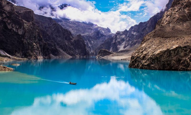
The 2010 Attabad landslide remains a stark reminder of nature’s tipping point. A massive landslide blocked the Hunza River, submerging villages and severing the Karakoram Highway.
The turquoise lake that formed is now a tourist attraction, but the disaster reshaped lives overnight and exposed the fragility of mountain ecosystems.
Survival on thin ice
For families across Gilgit-Baltistan, uncertainty has become a daily companion. They farm fragile plots, tend livestock along unstable slopes, and remain alert to the sound of warning sirens echoing through narrow valleys.
Life unfolds between ice above and water below, where survival depends as much on vigilance as on tradition.
Sohail Maqpoon, who hails from Gilgit-Baltistan and now lives in Islamabad, says this uncertainty defines life in Pakistan’s high mountains.
He stresses that the country needs long-term climate policies that centre mountain communities, invest in scientific research, and ensure climate finance reaches those living on the edge.
“Pakistan did not cause climate change, yet it bears a disproportionate burden of its consequences.”
For now, families continue to live between ice and water — hoping their warning signals are heard before it is too late.