

Key Points
- Persistent dry spell grips most regions under continental air
- Westerly wave to bring brief rain and snow to northern highlands (Nov 4–5)
- Moisture pulse to revive soil and aid rabi sowing in rain-fed zones
- Smog-fog intensifies over Punjab plains amid stagnant air
ISLAMABAD: For much of the country, the last weeks have been suffused with a relentless dry spell — continental air dominating the scene, skies staying mostly clear, and the land waiting.
According to the Pakistan Meteorological Department’s National Weather Forecasting Centre (NWFC) weekly outlook, from 31 October through 2 November, dry weather is expected over most parts of Pakistan, with cold nights already setting in across hilly areas. nwfc.pmd.gov.pk+1
Then comes the pivot: from 3–5 November, a faint but critical change—a westerly wave approaches, and by 4 November, rain and mountain snow are forecast for the upper reaches (Gilgit Baltistan, Upper Khyber Pakhtunkhwa, the Pothohar region and Islamabad) while lower plains remain dry. nwfc.pmd.gov.pk
The backdrop: A monsoon like no other
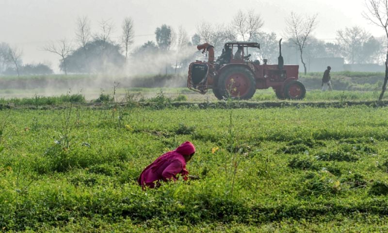
Earlier this year, Pakistan experienced an unprecedented monsoon (in parts of the country) — heavy rains, floods, saturated rivers, and widespread waterlogging. While that deluge brought havoc, it also replenished reservoirs and soil moisture in places. But now the transition into the drier late-season period has some serious implications for the upcoming rabi (winter) cropping season, especially in rain-fed areas.
Why this “wet break” matters — especially now
Here are several ways the forecasted rain/snow break could be a game-changer for farmers and the land:
Recharging soil moisture: In rain-fed zones, the absence of irrigation means reliance on stored soil moisture. The dry spell has left many fields with shrinking moisture reserves; the expected precipitation over highlands may help groundwater and hill-catchments receive a top-up, indirectly feeding down into springs and seepage zones.
Reservoir and canal boosts in uplands: The mountain snow forecasted for Gilgit Baltistan and upper KP will eventually melt and feed the headwaters of rivers that feed canal networks and surface flows downstream. For the rabi crop, particularly wheat in the Pothohar and adjoining rain- fed blocks, that means better assurance of water when it’s needed.
Timing matters: The fact that the rain/snow is concentrated on 4 November in the upper areas, while the rest of the country remains largely dry, means that this is a targeted recharge event rather than a full-blown wet spell that might disrupt harvest or sowing. It gives a pulse of moisture without the downside of waterlogging or delay.
Optimising the sowing window: With clear skies now, farmers in rain-fed areas have had the chance to ready their land, clear residues, and prepare seedbeds. The upcoming moisture injection can be the push needed to align moisture availability with the sowing of rabi crops.
Mitigating dry-spell risk: The prolonged dry conditions before this have caused soil desiccation, cracks, compaction and slower germination potential. A well-timed light rain/snow event helps break surface crusts, improve infiltration and improve conditions for stand establishment.
But there’s a caveat — and widespread contrast
While upland and upstream zones get that needed refresh, many plain and rain-fed areas, especially in parts of Punjab and Sindh, will continue under dry skies. The NWFC outlook flags that smog/fog is likely to dominate the eastern districts of Punjab throughout this period.
And for those plains that didn’t get sufficient summer or monsoon rainfall (or where irrigation infrastructure is weak), the dryness may still leave them marginalised, unless that brief upland recharge triggers downstream benefit quickly.
A narrative: From monsoon excess to productive lull, to strategic wet burst
The monsoon came, and the waters surged. Then came the calm — clear skies, cold nights, dust accumulating, farmers holding their breath. The land dried, the reservoirs sit heavy, but the soils in the plains lighten and crack. The air in the east thickens with smog and fog — a stifled sigh.
Now: the forecast says — hold on; A westerly wave approaches. On 4 Nov, high mountains will hear rain, and snow will blanket peaks. The cloud curtain lifts, the catchments sigh. The meltwater begins. The rain-fed fields in Pothohar and the uplands may drink from the skies again. That’s the break — the spell-breaking moment. Not a deluge, but a meaningful drink.
For rain-fed agriculture, this break could make the difference between a fragile sowing and a robust one. Crops like wheat, barley, and masoor (lentils) in the upland rain-fed zones will particularly benefit from this moisture nod. For irrigated sectors, it’s a backup—less urgent perhaps—but for those in the rain-fed margins, it’s a lifeline.
Key takeaways for farmers & policymakers
Rain-fed farmers should prepare for sowing soon after the moisture pulse — seed, seedbeds and land prep should be primed.
Irrigation managers in upland catchments should monitor headwaters and storage inflows post-4 Nov to take advantage of potential inflows.
Eastern plains districts worry about smog/fog — poor air quality may affect human health and also hamper early-morning farm operations; precautions needed.
Extension services should highlight that while uplands get benefit, plains do not receive the same boost—so target support (e.g., short-term irrigation aid, soil moisture conservation) should focus on dry-zone rain-fed blocks.
For policymakers: This upcoming break is a chance to shift from the monsoon recovery phase to the sowing-readiness phase. Ensuring that infrastructure (canals, bunds, check-dams) is ready to capture that melt/rain is essential.
In short, after the dramatic monsoon and then a long, dry pause, Pakistan stands on the cusp of a strategic wet break. It may be subtle — few plain areas will see major rain — but in the uplands and rain-fed zones, that 4 November wet burst could mark the turning point for the rabi season. The land is poised. The skies are about to open. For many farmers, this could spell stability instead of struggle.