

Key points
- Project uses LLM with Google Earth Engine integration
- Model fetches spatial data via natural language prompts
- Team secured Google DeepMind grant to develop tool
ISLAMABAD: In 2024, Ahmed Iqbal and Hanzila Bin Younus, students at Islamabad’s Institute of Space Technology, faced a choice while working on their final-year project for their bachelor’s degree in space sciences.
They could either treat the assignment as a simple graduation requirement, or aim to develop something that might even capture the attention of a tech giant like Google.
They chose the ambitious route, which led to the creation of GeoGemma — an open-source Large Language Model (LLM) integrated with Google Earth Engine, enabling users to analyse satellite imagery and spatial data without writing complex code.
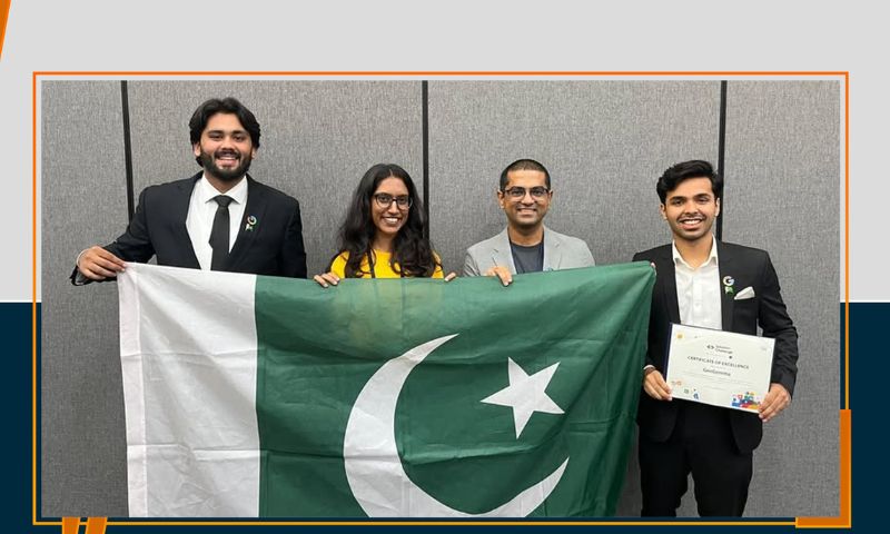
Last week, GeoGemma earned the “Best AI Use Case” award at the Asia-Pacific (APAC) Solution Challenge, jointly hosted by Google and the Asian Development Bank in Manila.
Automating geospatial analysis
Speaking to the local from Manila, Iqbal shared that GeoGemma was developed with the goal of automating geospatial analysis.
“Google Earth Engine provides regularly updated satellite images from across the globe — that’s around 80 petabytes of data,” he said. “You can overlay maps to evaluate various geographical factors — from temperatures atop K2 to thermal imaging.”
🏆 Proud Moment for IST & Pakistan! 🇵🇰
Team GeoGemma from the Institute of Space Technology (IST) has won the prestigious Google Challenge Award 2025 – Best AI Use Case in Manila, Philippines!
Among global finalists, their innovation stood tall — showcasing Pakistan’s brilliance… pic.twitter.com/pGKbRsW6ne— PTV News (@PTVNewsOfficial) June 27, 2025
However, the platform has its limitations. Users require a certain degree of programming knowledge to extract and analyse the data effectively.
GeoGemma was designed to eliminate that barrier, allowing users to retrieve and interpret spatial data by simply entering prompts in natural language. With financial support from Google, the team was able to bring this vision to life.
Research grant opportunity
In mid-2023, Iqbal discovered a research grant opportunity under the Gemma Academic Programme, led by Google DeepMind, an AI research subsidiary of Google’s parent company, Alphabet.
Iqbal, Younus, and their supervisor, Dr Sajid Ghaffar, formed a GeoAI team and submitted a proposal to merge Google Earth Engine with the open-source Gemma model.
In September 2024, they were awarded a $10,000 research grant from Google DeepMind.
From 750 entries submitted by more than 200 universities, GeoGemma was chosen among the top 10 projects. Another Pakistani team — from FAST University — also made the top 10 for creating a Gemini-powered document editor designed for neurodivergent users.
Key strength
To scale their project for the global stage, the original duo brought in two additional team members: Abdullah Asif, a front-end web developer, and Khaleelullah, who took on the role of tech lead and AI engineer — both undergraduates in Computer Science at IST.
GeoGemma’s key strength lies in its simplicity. Iqbal described it as a spatial analysis tool that can interpret natural language prompts to fetch satellite data.
“We’re pushing the envelope by designing a lightweight model that doesn’t need servers — it’s under 2GB and can run on any laptop,” he said.
Remote sensing
He added that remote sensing and satellite imagery are vital to a range of sectors — from sustainability and real estate to supply chains and the oil and gas industry.
The team aims to launch GeoGemma before the end of the year.
“At present, we’ve built a strong foundation. We’ve received recognition and credibility. Looking ahead, there’s tremendous potential to collaborate with various industries and develop proprietary tools tailored to their needs,” Iqbal said of GeoGemma’s future.